

By Ralph
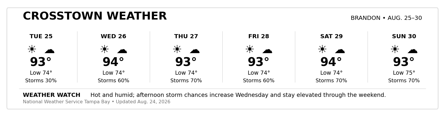
Brandon is heading into another very typical late-August weather pattern this week: low 90s during the day, warm nights and recurring chances for afternoon thunderstorms.
Tuesday through Saturday, forecast highs remain tightly clustered around 91–92°F, with overnight lows generally in the low-to-mid 70s. Sunday should be around 90°F. The recurring feature is moisture—showers or thunderstorms are possible throughout the week, with Friday and the weekend looking particularly unsettled. Weather Watch
The biggest practical concern isn't simply the temperature. Heat, humidity and afternoon storms will be the combination to watch.
Friday through Sunday currently carries substantial thunderstorm chances. The weekend forecast calls for roughly a 60–70% chance of rain or thunderstorms, particularly during the afternoon.
Lightning can also develop quickly with Florida summer storms, so outdoor plans shouldn't rely solely on what the sky looks like when you leave home.
Planning Ahead
If you have yard work, exercise or other outdoor activities planned, morning remains your better window.
Keep water nearby, take breaks from the heat and have an indoor alternative for afternoon activities—especially heading into the weekend.
And, as always during Florida's rainy season: Don't drive through flooded roadways. Turn around and find another route.
|
0 Comments
Join the conversation
Be the first to comment
Share your thoughts above.