
Brandon’s 7-Day Forecast: Rain and Storm Chances Return This Week |
A relatively quiet start gives way to a wetter pattern, with showers and thunderstorms becoming more common as the week progresses. |
By Ralph
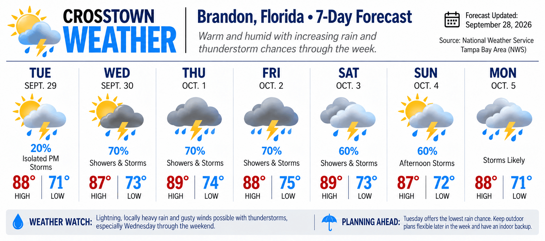
Brandon begins the week with a bit of a break from our usual late-September thunderstorms, but don't put the umbrella away just yet.
The National Weather Service Tampa Bay says the drier air we've enjoyed is beginning to move out, with moisture—and our familiar afternoon showers and thunderstorms—returning. Tuesday: The Best Bet for Outdoor Plans
Tuesday, Sept. 29 should be the week's quieter day.
Brandon can expect partly sunny skies with temperatures climbing into the upper 80s. The National Weather Service puts the chance of rain at only 20%, primarily from isolated afternoon showers and thunderstorms. Winds should remain light.
If you've got yard work, errands or other outdoor plans waiting, Tuesday looks like the day to get them done. Wednesday: The Pattern Begins to Change
By Wednesday, rain chances increase considerably.
The latest NWS forecast calls for numerous showers and scattered thunderstorms, with highs remaining in the upper 80s.
This doesn't necessarily mean an all-day washout. Florida thunderstorms can be highly localized, so one Brandon neighborhood may get a downpour while another sees considerably less.
But the chances of encountering rain will be substantially higher than Tuesday. Thursday and Friday: Keep the Umbrella Close
The wetter pattern continues Thursday.
Expect mostly cloudy conditions with numerous showers and scattered thunderstorms, temperatures in the upper 80s and overnight lows generally in the 70s.
By Friday, the National Weather Service continues to indicate a high likelihood of showers and thunderstorms across the area.
For Brandon residents, that means the familiar Florida routine:
Make your outdoor plans—but have an indoor Plan B. The Weekend Stays Unsettled
Saturday isn't offering much relief.
The current extended outlook continues the pattern of numerous showers and scattered thunderstorms, with warm and humid conditions remaining in place.
Conditions can change considerably several days out, so we'll treat the weekend portion of the forecast with more caution than Tuesday or Wednesday. Don't Expect Fall Just Yet
The calendar says autumn.
Brandon's thermometer apparently hasn't received the memo.
The National Weather Service notes that across west-central Florida, highs in the mid-80s to lower 90s and humid conditions commonly persist well into October.
Historically, the region's first meaningful arrival of cooler, drier air tends to occur around the middle of October, and sustained cooler weather generally takes longer.
So although October arrives Thursday, we're still looking at a very Florida-like combination:
Upper 80s. Humidity. Sunshine. Clouds. And afternoon thunderstorms. Weather Watch
Any thunderstorm can produce lightning, locally heavy rainfall and gusty winds. If thunder can be heard, lightning is close enough to pose a danger.
Drivers should also use caution during heavier downpours, particularly where water begins accumulating on roadways. Planning Ahead
Tuesday currently offers the best opportunity for outdoor activities.
Beginning Wednesday, keep plans flexible and watch the sky—especially during the afternoon and evening hours.
And as we move deeper into the week, remember that thunderstorm timing and coverage can change. Check the latest forecast before outdoor events rather than relying on a forecast made several days earlier.
For now, Brandon's forecast can be summed up pretty simply:
Enjoy Tuesday. Keep the umbrella handy after that. And don't unpack the sweaters yet. |
0 Comments
Join the conversation
Be the first to comment
Share your thoughts above.